GRAVÜR DÜNYASI
Digital Engraving Library
| Artist | Jean Baptiste Bourguignon D'Anville (1697-1782) |
| Engraver | Joseph Bye (1779-1817) |
| Date | 1808 |
| Technique | Copper Engraving |
| Category | Maps |
| Source | London Published By F.C. And J.Rivington July 1 1808 |
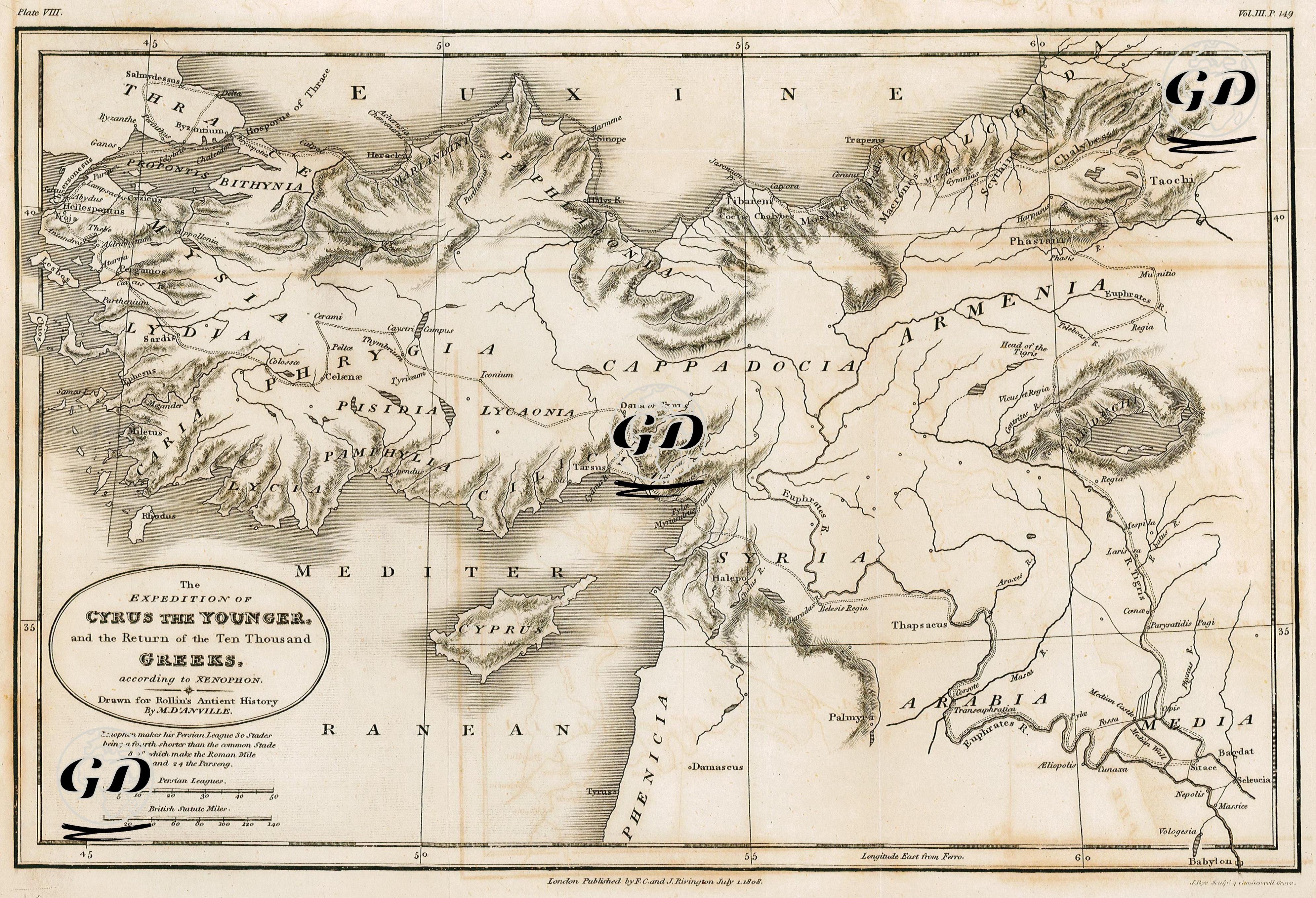
This map dated 1808 was prepared based on the expedition described in Xenophon's work "The Return of the Ten Thousand" (Anabasis). This geographical depiction visualizes the campaign of the young Persian prince Cyrus, who, along with Greek mercenaries, led a campaign against his brother Artaxerxes II in 401 BC to seize the Persian throne, as recounted by Xenophon. The subsequent defeat of Cyrus's death, and the subsequent great retreat (Anabasis) of approximately 10,000 Greek soldiers who advanced with him into Mesopotamia, attempting to cross enemy territory and reach the Black Sea coast, were the two main forces. The dotted lines on the map represent the route of this military expedition, both forward and backward. The expedition began from the city of Sardis in Lydia (near present-day Manisa-Salihli), the camp of the Persian prince Cyrus. Sardis was where Cyrus assembled his army. The army advanced eastward through Iconium (modern-day Konya) through Phrygia. On the map, this region is divided into Lycaonia and Pisidia. These were regions inhabited by semi-independent Anatolian tribes, far removed from the Greek world. The army then descended southeastward, passing through Tarsus and the Cilician Gates. This point was crucial because it consisted of narrow passes and was strategically difficult to capture. Cyrus's army encountered diplomatic and logistical difficulties in passing through these areas. The expedition continued into Mesopotamia (modern-day Iraq) via places such as Thapsacus, where the Euphrates River flows. This crossing point, shown in detail on the map, was one of the most challenging and risky phases of the campaign. Near Cunaxa, east of the main target, the Persian capital of Babylon, Artaxerxes II, brother of Cyrus the Younger, was encountered. The Battle of Cunaxa was fought here, and Cyrus lost his life. This area is shown on the map as the area east of the inscriptions "Babylon" and "Media." Having lost its leadership with the death of Cyrus, the army initiated the famous "return of the ten thousand" (Anabasis) process, in which 10,000 Greek soldiers, who found themselves surrounded in enemy territory, elected new leaders from among themselves and returned northwards, that is, towards the Black Sea. The return route on the map is also shown with dotted lines. This dramatic return was carried out over the mountainous regions of eastern Anatolia, traversing difficult snowy passes in the dead of winter. After months of marching, the army reached the Black Sea coast and finally Trapezus (Trabzon) on the Black Sea coast; the cry of "Thalatta! Thalatta!" (Sea! Sea!) is etched in military historiography as an iconic moment. In the following phase, the mercenaries advanced westward along the Black Sea coast, reaching port cities such as Cerasus (Giresun), Kotiora (Ordu), Sinope (Sinop), Heraclea Pontica (Karadeniz Ereğli), and finally Byzantium (Istanbul). Some units returned by land via Bithynia and Thrace (Thrace). This line, shown at the western end of the map, represents the final stage of the campaign. This is the period when the soldiers engage in conflicts with some local tribes and receive offers of service as mercenaries again. Thanks to Xenophon's unique narrative, the Anabasis not only stands as a significant work of military literature in antiquity, but also serves as an unparalleled source for strategy, leadership, and geographic knowledge. The map meticulously depicts every stage of this great march, conveying to the viewer both the spatial and historical reality of the period through the place names, rivers, mountains, and ports along the route.