GRAVÜR DÜNYASI
Digital Engraving Library
| Artist | John Rapkin(1815-1876)-Henry Winkles(1801-1860) |
| Engraver | John Rapkin (1815-1876)-Henry Winkles (1801-1860) |
| Date | 1855 |
| Technique | Steel Engraving-Original Hand Colored |
| Category | Maps |
| Source | The History of the War With Russia: Giving Full Details of the Operations of the Allied Armies by Henry Tyrrell - The London Printing And Publishing Company |
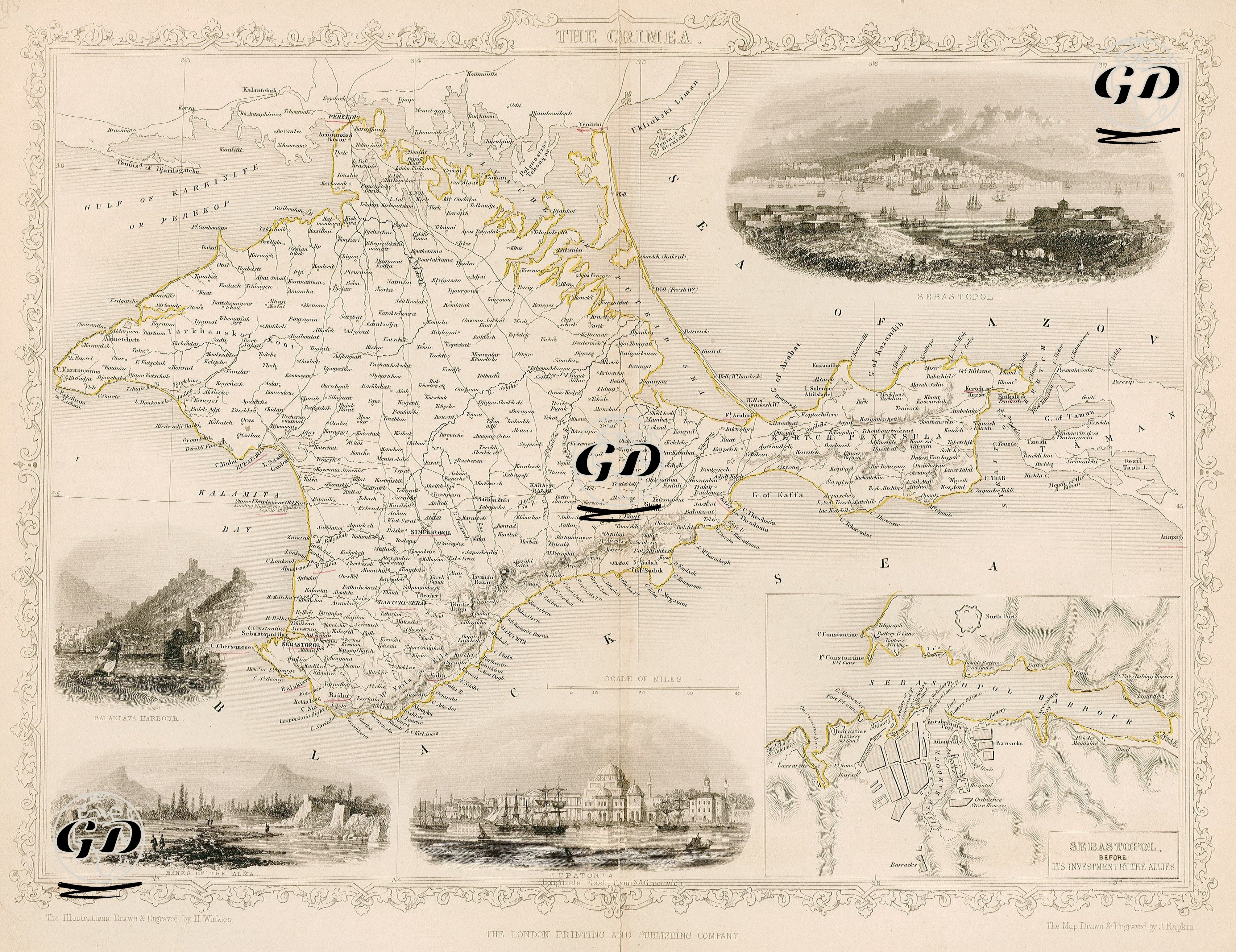
This map shows the Crimean Peninsula in detail and especially the strategically important areas during the Crimean War (1853–1856). The map not only provides geographical information, but also serves as a propaganda and information map, enriched with visual depictions of the siege of Sebastopol (Sevastopol) at the center of the war. The map covers the entire Crimean Peninsula and is bordered by the Perekop Isthmus to the north, the Black Sea coast to the south, the Kerch Strait to the east and the Kalamita Gulf to the west. Cities and towns are named in detail: important centers such as Simferopol, Bakhchisaray, Feodosia, Kerch, Yalta, Yevpatoriya, Sebastopol are located on the map. The small engravings on the map also indicate: 1. Balaklava Port, the critical port where the British forces were based. This small port was of strategic importance throughout the war as the main entry point for the British supply line. 2. The banks of the Alma River are the site of the first major battle between the Allies and the Russians on September 20, 1854 (Battle of the Alma). 3. Evpatoria (Gözleve), a port city under Ottoman rule, was where the Allies first landed in Crimea in September 1854. 4. Shows the plan and defensive structure of the city of Sebastopol before it was besieged by the Allied forces. The port area, fortifications (Fort Nicholas, Fort Constantine), shipyards and urban texture are described in detail. 5. A panoramic engraving showing the general view of the city of Sevastopol. This scene, drawn from a view from the sea, includes naval vessels, fortresses, the city skyline and defensive lines. This map and the surrounding illustrative scenes document not only the military, but also the topographic, urban and logistical aspects of the Crimean War.