GRAVÜR DÜNYASI
Digital Engraving Library
| Artist | John Arrowsmith (1790-1873) |
| Date | 1841 |
| Technique | Copper Engraving-Original Hand Colored |
| Category | Maps |
| Source | London Published Jan. 2 1841 By J.Arrowsmith Hydrographer To Her Majesty No.10 Soho Square |
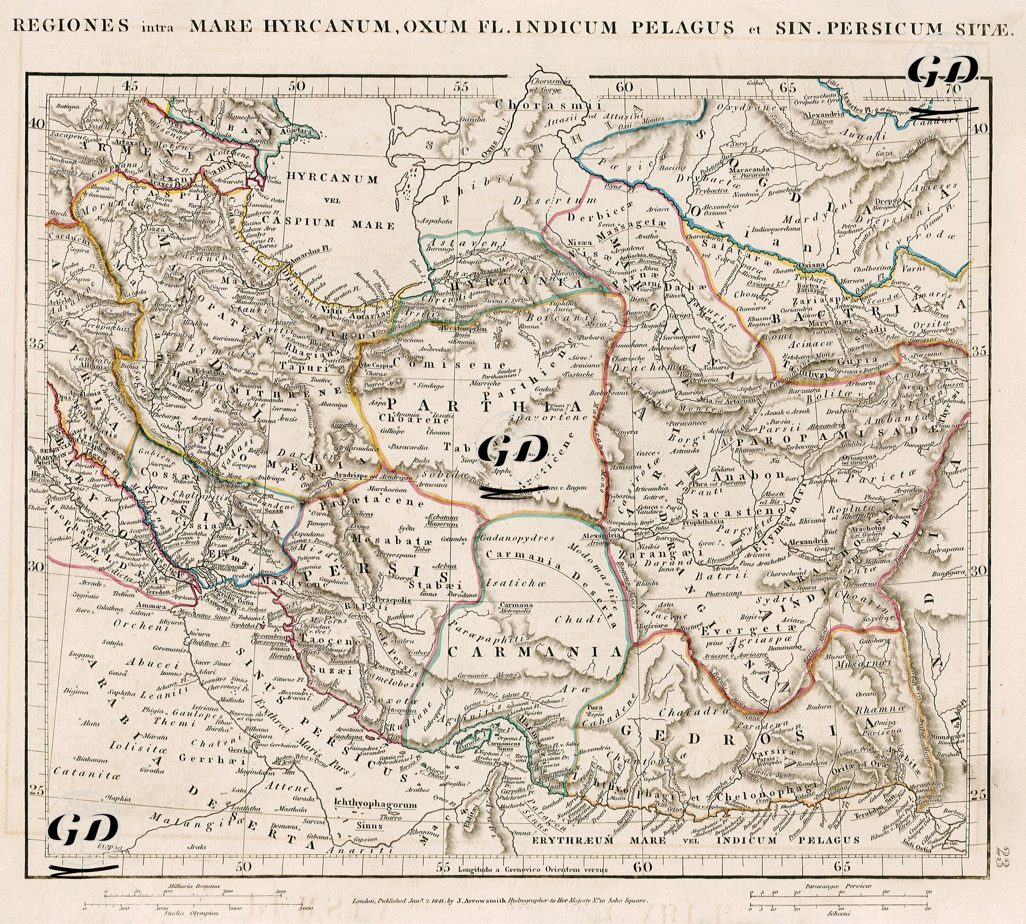
This map is a cartographic study drawn from the perspective of classical geographers and describes the region with the names used in ancient Roman, Greek and Persian sources. The title of the map is Latin and means "the areas between the Caspian Sea (Mare Hyrcanum), the Oxus River (Oxus Fl.), the Indian Ocean (Indicum Pelagus) and the Persian Gulf (Sinus Persicus)". The map covers a very wide geography including modern Iran, Afghanistan, Turkmenistan, Uzbekistan, the north of Pakistan and the area around the Persian Gulf. Parthia, the lands of the Parthian Empire, is located in the center of the map; ancient regions such as Hyrcania and Sogdiana are located in the north, Bactriana, Aria, Drangiana in the east, Carmania, Gedrosia and Persis in the south, and Assyria and Media in the west. This map is inspired by the works of ancient writers such as Strabon, Pliny and Ptolemy, especially those written in the Hellenistic and Roman periods, and the geographical information systems they describe. The borders and place names on the map are based on ethnic, administrative and cultural regions rather than modern nation-states. For example, regions such as Persis, Media, and Carmania in present-day Iran were of central importance during the Achaemenid and Sassanid periods, while Parthia represented the core region of the Parthian Empire, which expanded from the 3rd century BC onwards. Regions such as Sogdiana, Bactriana, and Margiana along the Oxus River (today's Amu Darya) in the northeast of the map are key to both ancient trade routes and early versions of the Silk Road. These regions were also where the Greco-Bactrian Kingdom was founded. Arachosia, Drangiana, and Gedrosia in the east were important stops on Alexander the Great's route during his expedition to India, and the map aims to match the topography with these historical events. The coastline along the Persian Gulf (Sinus Persicus) and the Indian Ocean (Mare Indicum) bears traces of ancient maritime routes and trade routes. Gedrosia (modern-day Baluchistan) in the south contains the harsh landscape depictions of classical geography, referring to Alexander the Great's difficult desert crossing. Mountains, rivers, coasts and borders are often depicted with fine hatching and colored lines. It is a prominent example of the neoclassical cartographic style common in 18th and 19th century Europe. Political boundaries are separated by colored contour lines, but these lines do not represent modern boundaries but rather represent ethnocultural regions and ancient administrative divisions. The ancient regions on the map show a significant historical continuity when compared to their modern geographic counterparts. Ancient Parthia corresponds to present-day Khorasan in northeastern Iran, while Persis overlaps with present-day Fars Province in southern Iran. Media encompasses Hamadan and its surroundings in western Iran. The region called Hyrcania refers to the provinces of Mazandaran and Gilan on the southern coast of the Caspian Sea, while Carmania corresponds to Kerman Province in southeastern Iran. The Baluchistan region of Pakistan was known as ancient Gedrosia, and Kandahar and its surroundings in southern Afghanistan were known as Arachosia. Drangiana corresponds to the Helmand region in southwestern Afghanistan; Aria overlaps with Herat and its surroundings to the west. Bactriana corresponds to northeastern Afghanistan and southern Uzbekistan; Sogdiana to northern Uzbekistan and western Tajikistan; Margiana to the Merv area in southern Turkmenistan. Assyria in northern Iraq covers the Mosul area, Babylonia covers the Baghdad-Basra area in central and southern Iraq. Susiana corresponds to the Khuzestan Province in present-day southwestern Iran, and Chaldaea corresponds to the Tigris-Euphrates delta region in southern Iraq. Scythia covers the steppes of Central Asia, especially Kazakhstan and southern Russia. Finally, Elymais represents a mountainous area in southwestern Iran, and the Zagros Mountains represent an important mountain range between Iran and Iraq.