GRAVÜR DÜNYASI
Digital Engraving Library
| Date | 1870 |
| Technique | Steel Engraving |
| Category | Maps |
| Source | William Mackenzie Glasgow, Edinburgh & London |
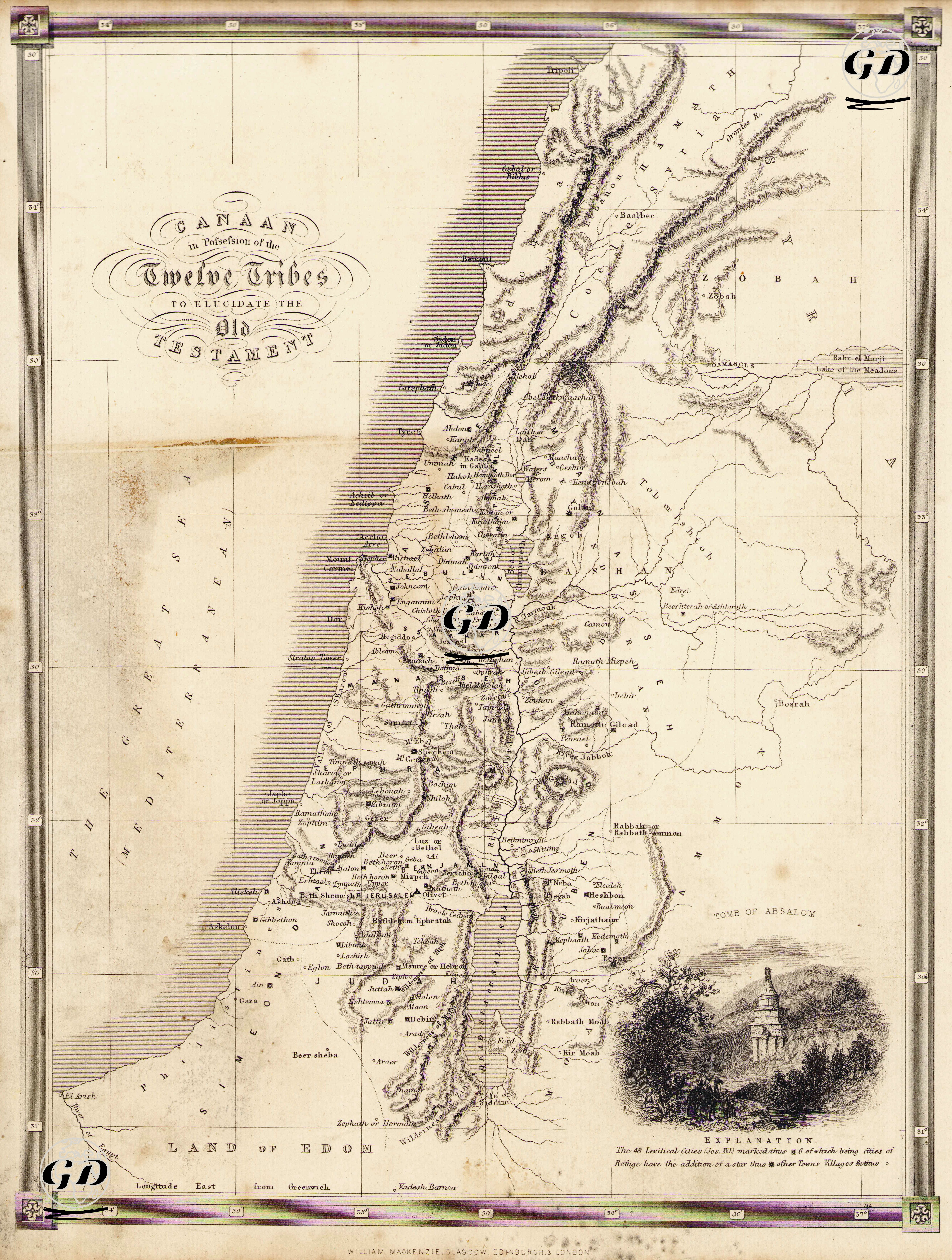
This map is a historical-geographical engraving map based on the sacred text. The map visualizes how the Land of Canaan (Canaan) mentioned in the Old Testament (Tanakh/Torah) was divided among the Twelve Tribes after the Israelites settled in the region after their Exodus from Egypt. The main purpose of the map is to explain the geographical narratives in the Biblical texts, especially the settlement areas, mountains, rivers, tribal borders and places where important events took place in the books of Joshua, Judges, Samuel and Kings, in a topographical and political way. The map covers an area covering the present-day lands of Israel, Palestine, Jordan and Lebanon. The Mediterranean forms the western border, while in the east the Jordan River, the Dead Sea and beyond it other kingdoms and tribal lands frequently mentioned in the Old Testament such as Moab, Ammon and Edom are shown. In the north are the Lebanon Mountains, Phoenician and Aramaic city-states such as Baalbek and Zobah, while in the south are the lands of Bersheba, Kadesh Barnea and Philistia. In the center of the map are cities that are both sacred and historically critical, such as Shiloh, Gilgal, Betel, Jericho, Hebron, and Jerusalem. Tribal areas are marked separately on the map: for example, the tribe of Judah is in the south, Ephraim and Manasseh are in the middle, and tribes such as Dan, Benjamin, Issachar, Zebulun, Asher, and Naphtali are in the north and along the coast. This division is based on the distribution of the land inheritance given to the Israelites by God through Moses in the Old Testament. In addition, there is an "Explanation" section at the bottom of the map, where 48 Levitical cities are marked with a square symbol according to Joshua 21, and 6 of these are cities of refuge, with a star next to them. Other cities, villages, and towns are marked with a circle symbol. These symbolic markings are important in showing the locations of cities reserved for the Levites (priestly class) in the Old Testament. A small engraving in the lower right corner of the map depicts the structure called the Tomb of Absalom. This image is based on the historical structure in the Kidron Valley in Jerusalem, traditionally attributed to King David’s rebellious son Absalom. Such iconographic additions make the map not only a geographical but also an archaeological and theological document.