GRAVÜR DÜNYASI
Digital Engraving Library
| Artist | John Rapkin(1815-1876) |
| Engraver | John Rapkin (1815-1876) |
| Date | 1860 |
| Technique | Steel Engraving |
| Category | Maps |
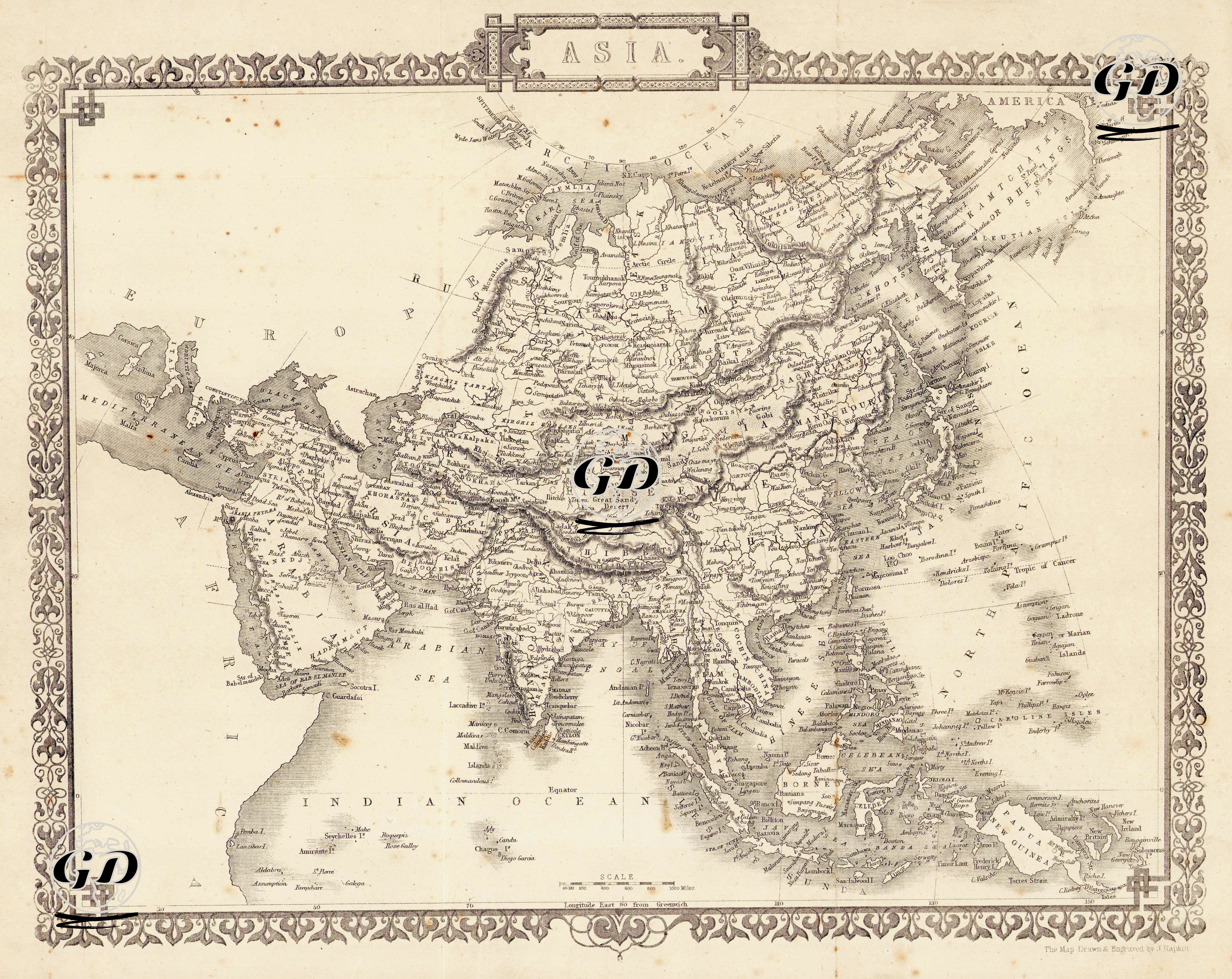
This map, dated to the mid-19th century and simply titled "ASIA," is a richly artistic woodcut detailing the political, geographical, and cultural aspects of continental Asia. The map frame is adorned with period decorative ornaments, and the borders reflect a stylized Victorian aesthetic. Political and geographical boundaries are clearly delineated by dotted lines separating countries. Cartographically, the map covers the Asian continent in detail, from the eastern borders of Europe to the Japanese archipelago. It is also bordered by Siberia to the north, the Indian Ocean to the south, the Middle East to the west, and the Pacific Ocean to the east. Ottoman lands are designated as "Turkey" from Mesopotamia to the coast of the Levant, but the term "Turkey in Asia" is omitted. Iranian lands are designated as "Persia," and the Arabian Peninsula is generally referred to as "Arabia." India is designated as "India," and no separate designation is used to suggest British rule within the region. China is written directly as “China” and the Tibet region is shown as “Thibet”. A large area in the north of the map is marked "Siberia," and the high mountain ranges and steppe areas below Siberia are carefully shaded. Independent countries such as Burma, Siam, Anam, Cambodia, and Cochin China are carefully named. Islands and archipelagos such as Sumatra, Java, Borneo, New Guinea, and the Philippine Islands are carefully placed; Japan, along with its neighboring islands, is shown as "Japan." The Bering Strait is designated "Behring's Straits," emphasizing the geopolitical connection between the northeastern tip of Asia and the Americas. Major rivers (the Ganges, Indus, Yangtze, Yellow River, etc.) and mountain ranges (the Himalayas, Hindu Kush, and Alborz) are detailed through shading on the map; major seas and gulfs such as the Indian Ocean, South China Sea, Arabian Sea, and Bay of Bengal are accurately marked. Major political entities of the period, such as Iran (Persia), Afghanistan, India, the Chinese Empire, Tibet, Siberia, and Japan, are clearly represented on the map. China is detailed with its vast territory and is directly supported by important physical geographic elements such as the Tibetan Plateau, the Himalayan Mountains, the Yangtze, and the Yellow River.